About CORONA
The 1950s was a time of great uncertainty for the US regarding the Soviet Union’s budding strategic nuclear forces. Although the US knew the Soviets had ambitious programs to develop and deploy intercontinental-range ballistic missiles (ICBMs) and bombers, the US knew little about the scope or success of Soviet efforts. The US frequently sighted Soviet strategic bombers and had evidence of Soviet missile test programs but lacked the means to get a comprehensive look at overall Soviet strategic deployments–the US did not know how many operational ICBMs and bombers the Soviets had and where they were deployed. The US Intelligence Community reflected this uncertainty in wild overestimates of Soviet bomber and missile production–the so-called “bomber gap” and “missile gap”–and forecast that the US was falling behind in the nuclear arms race and in real danger of nuclear attack.
Between 1956 and 1960, imagery from 24 U-2 photoreconnaissance aircraft missions over the Soviet Union opened up a crack in the Soviets’ armor, but the crack was a small one and it closed before a single ICBM base could be found. President Eisenhower halted all U-2 overflights of the USSR when the Soviets shot down an American U-2 and captured its CIA pilot Francis Gary Powers near Sverdlovsk on 1 May 1960.
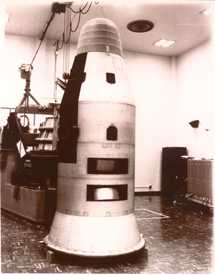
Part of the CORONA Satellite. The quality and value CORONA provided dramatically improved over its lifetime.
The CORONA Program began as a joint CIA-Air Force effort in the late 1950s. Cloaked in secrecy, it was known to the public as a scientific research program named DISCOVERER. The program’s goals were daunting: launch a large camera into earth orbit, photograph specific points and areas on the earth’s surface, parachute a capsule of exposed film to earth, snag the capsule in midair over the Pacific Ocean, develop the film, and search the images for answers to the nation’s pressing intelligence questions. Many things could go wrong–and did. The first 13 missions failed to return any useable imagery. Unsuccessful launches, orbits not achieved, camera malfunctions, spacecraft errors, and missed recoveries plagued the program.
Finally, on 18 August 1960, all systems on CORONA Mission XIV operated successfully! This remarkable technological achievement revolutionized the intelligence world by returning from space more photographic coverage of the Soviet Union in a single mission than in all previous U-2 missions combined.
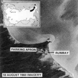
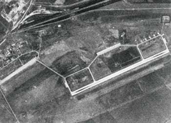
An image of Soviet Mys Shmidta Air Force Base in the former USSR, taken from CORONA.
The first CORONA images were grainy and of limited utility, but quality–and intelligence value–improved rapidly on succeeding missions. Within a few months, CIA photointerpreters had dispelled both the missile gap and the bomber gap. They found that Soviets were, in fact, significantly behind the US in development of a workable ICBM and that the Soviets were building up a strategic bomber force but were devoting most of their resources to missile production. In just a few weeks, CORONA photography had eliminated the Soviet intelligence dilemma that had haunted the US for a decade.
Over the years, the quantity, quality, and reliability of CORONA imagery improved, making it the single most important source of intelligence on Soviet strategic forces: missile launch complexes and test ranges, ballistic-missile submarine development and deployment, aircraft factories and air bases, anti-ballistic-missile activities, and air defenses. CORONA was also an invaluable source of intelligence on potential enemies in East Asia, the Middle East, and other areas of interest. In addition, the US Defense Department used CORONA imagery to produce military maps of denied areas more accurately than ever before.
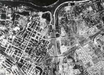
CORONA C’s imaging capabilities were unprecedented in US history.
CORONA enabled the US to specify verifiable terms of the Strategic Arms Limitation Treaty (SALT) with the Soviet Union in 1971. US negotiators confidently knew that photointerpreters could monitor changes in the size and characteristics of missile launchers, bombers, and submarines. Satellite imagery became the mainstay of the US arms-control verification process.
CORONA is a milestone in US history. Developers of this nation’s first film-return photoreconnaissance satellite explored and conquered many technological unknowns of space, lifted the curtain of secrecy that screened military developments within the Soviet Union and Communist China, and opened the way for the even more sophisticated follow-on imaging satellite systems. The 145th and final CORONA launch took place on 25 May 1972 with the final recovery on 31 May 1972. Over its lifetime, CORONA provided photographic coverage totaling approximately 750,000,000 square miles of the earth’s surface. This impressive capability was surpassed only by the quantity and quality of intelligence that it yielded. Without CORONA, the US may well have been misguidedly pressured into a World War III.
In addition to military activity intelligence, images captured CORONA C were also used to produce maps with impressive accuracy.
Videos
The Debrief: Behind the Artifact - CORONA Satellite
It’s hard to imagine a world without GPS or satellite imagery, but in the 1950s when the CIA created its first photo reconnaissance satellite, codenamed Corona, the technology simply didn’t exist.
Corona was America’s first successful photo reconnaissance satellite and it captured imagery from 1968 up until 1972.
The requirement for gathering intelligence over the Soviet Union increased dramatically after the Soviet Union shot down one of our U2 aircrafts and captured CIA pilot Francis Gary Powers. Two and a half months later on its first mission, Corona captured more imagery than all previous U2 flights.
Photo reconnaissance imagery is used for a variety of things, everything from assessing military forces to finding out the production of grain in the country. In this case Corona was really important because it helped us better understand the buildup of Soviet military power in-country.
Corona depended on the successful physical recovery of the film, like the film here and this canister from Corona, but it also needed to obtain the images safely from the air and get them back to the ground to be developed and that’s where this parachute bag comes into play. What would happen is, we would take the images they would get rolled onto the film and they would end up in a capsule or a bucket.
They would descend down to Earth with a parachute slowing it, once it was in a specific zone a plane would come with a trapeze-type hook and it would actually hook the parachute, reel it into the plane, bring it back to the ground, and CIA officers would develop the film. Running for 12 years, Corona recorded over eight hundred thousand images covering seventy two million square miles of ground, which historians and environmentalists are still using today. Most importantly, Corona showed that the Soviet Union’s bomber and missile buildup was not outpacing the Americans as some had feared, which allowed our President the opportunity to make better strategic and budgetary decisions.
The Corona program was incredibly successful, giving the United States the confidence to pursue arms control agreements, but it did so much more than record the landscape of the cold war. It was able to provide environmentalists a look at the Earth 10 years before any other country launched resource satellites.
CORONA: America's Eye in Outer Space
The 1950s was a time of great uncertainty for the United States regarding the Soviet Union’s budding strategic nuclear forces.
While the Soviets had ambitious programs to develop and deploy intercontinental ballistic missiles and bombers, we knew little about the scope or success of their efforts.
The US Intelligence Community reflected this uncertainty in wild overestimates of Soviet bomber and missile production and forecast that the US was falling dangerously behind in the nuclear arms race.
The CORONA Program began as a joint CIA-Air Force effort in the late 1950s.
Cloaked in secrecy, the program’s goals were daunting: launch a large camera into earth orbit, photograph specific targets, return a capsule of exposed film to earth by parachute, retrieve the capsule in midair over the Pacific, and search the processed images for answers to the nation’s most pressing intelligence questions.
Many things could go wrong—and did.
The first 13 missions failed.
Finally, in August 1960, CORONA XIV revolutionized the business of intelligence by returning from space more photographic coverage of the Soviet Union in a single mission than in all previous U-2 overflights combined.
The first CORONA images were grainy and of limited use, but quality—and intelligence value—improved rapidly.
CIA photointerpreters found that the Soviets were, in fact, significantly behind in the development of a workable ICBM and that their strategic bomber force lacked significant resources.
In just a few months, CORONA closed the missile and bomber gap that had haunted the United States for a decade.
Over the years, CORONA became the single most important source of intelligence on Soviet strategic forces, including missile launch complexes, ballistic-missile submarine deployment, air bases, and air defenses.
In 1971 CORONA enabled the US to specify verifiable terms for the Strategic Arms Limitation Treaty.
Negotiators were confident that photointerpreters could monitor changes in the size and characteristics of missile launchers, bombers, and submarines.
Satellite imagery became the mainstay of the US arms-control verification process.
The final CORONA capsule was recovered in May 1972.
CORONA is a milestone in US history.
Developers of the nation’s first film-return photoreconnaissance satellite conquered the technological unknowns of space, lifted the curtain of secrecy that screened the Soviet Union and Communist China, and opened the way for the even more sophisticated satellite imaging systems in use today.
